
Mineral exploration software
Our sophisticated range of products can take you from assessing ground for prospectivity and acquisition through to drilling and basic resource modelling of your mineral assets. Enhance your productivity with our advanced tools that are constantly evolving to make sure they always meet the ever-changing demands of the exploration industry.


LandTrack Systems’ software is designed to provide solutions to help you acquire, protect, manage, report, and track mineral title compliance, tenure related agreements and environmental conditions. It allows you to effortlessly wrap compliance and business processes around your tenure management.
LandTrack Systems also delivers practical tenure compliance training designed to grow your knowledge and skill set, so you are more confident, effective, and efficient in preserving a company’s key assets; providing Directors further confidence with tenure security.
An integrated asset, tenement, agreement, and environmental data management system that provides the mining industry with its exclusive and innovative technology.
LandTracker secures your company’s tenements by providing audited data that seamlessly integrates tenure compliance requirements into your organisation’s procedural processes.
LandTracker Enviro streamlines the management of key environmental regulatory approvals and compliance activities. Its customisable interface ensures your environmental risks are appropriately managed and adapted to your company’s unique requirements thereby improving your environmental performance.
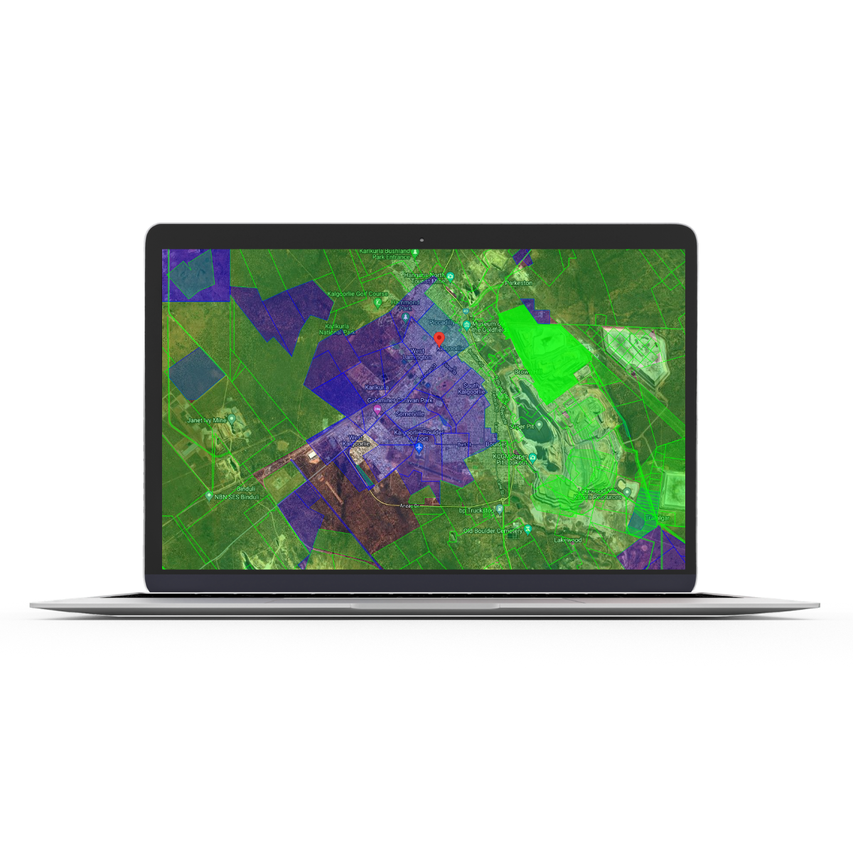
LandTracker Maps is a convenient, practical web application which enables you to see up-to-date details of all mining tenements across the whole of Australia.
This solution is provided free of charge and based on Google Maps, designed to work on your PC, tablet or mobile phone. It is loaded with details of mining tenements, updated daily from key government databases.
GeoSearch is a powerful land monitoring web-based GIS application designed to give you a competitive edge by identifying land as it becomes available across Australia for exploration, by monitoring tenement changes defined in areas of interest.
It provides up to the minute email alerts of newly available land by monitoring surrendered and withdrawn tenements and reporting on other tenement changes.
Expenditure Watch fills the gaps between the accounting system, tenement administration and exploration planning.
It is designed specifically to address difficulties with traditional tenement expenditure reporting.
Tenement Safety Net is a special purpose web application specifically designed to help mining companies protect their most valuable assets – their tenements – by providing an independent, timely and concise report to back up any tenement management system.
This free, multi-jurisdiction tenement management Wiki is an unmatched open resource for tenement managers, and other roles in mining or exploration that intersect with tenure management.
It’s a comprehensive knowledge base for you to tap into, learn from and share information – remaining relevant and acting as a valuable learning tool.

Discover
Exploration GIS suite
The ever-popular Discover exploration software is now compatible with two of the industry leading GIS platforms MapInfo Pro and ArcGIS Pro. Both versions are fully integrated with the must-have field mapping app Discover Mobile.

Discover for MapInfo Pro is an Exploration focused product, assisting the exploration professional in their daily activities from data conversion, map making to field work. Discover is bundled with the industry leading MapInfo Pro tools we all know, and domain focused exploration functions.
Exploration geologists acquire data from a multitude of sources and in a variety of formats. Data conversion and transformation is paramount to a speedy workflow. MapInfo Pro and Discover can import most spatial formats and industry specific data types and export back into these formats. From the rich range of available import and export formats, MapInfo Pro and Discover will simplify your daily tasks.
Discover is packed with vast array of analytical tools such as GraphMap, Data Classification, Correlation Matrix, Hydrological Analysis and Geophysical surface grid filters. These are just a subset of the available analytical tools. Whether it’s vector, image or surface datasets Discover has a tool to analyse and enrich your data.
MapInfo Pro and Discover have all the annotation tools for creating professional quality map outputs. Scalebars, titleblocks, map grids, map adornments, labels along with the popular and easy to use Scaled Layout tool for simple production of scaled templated maps.
Convert your drilling data collected in the field into spatially correct cross sections. The drillhole module contains all the tools for displaying and analysing your geophysical, assay and lithological downhole data. Want to plan your next drilling campaign, Discover has all the tools for laying out your traverse lines and all the subsequent analysis. To complement your drillhole data is the ability to display in Discover 3D.
Laptop, Tablet or a Mobile Phone, Discover can collect all your field data. If you want to collect data on a Windows tablet use the inbuilt GPS functionality in Discover. Prefer to use your Android or Apple phone/iPad to collect data we have the Discover Mobile app as the solution. Plan and design your field collection with the Sample Planer and Gridline Planner tools. Want to validate your data entry, use the user-defined picklists and table validation rules. The great thing about all our field solutions is the integration, with no messy data conversions between a multitude of apps.
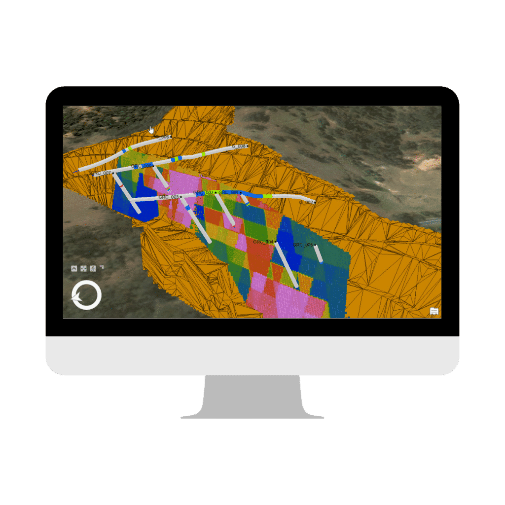
Discover 3D brings all your spatial data into a 3D GIS environment, with no clunky manual data conversions.
Discover for ArcGIS Pro brings all the Exploration focused tools we know from Discover to an Enterprise platform. Incorporated in the industry leading ArcGIS Pro, Discover assists the exploration professional in their daily activities from data conversion, map making to field work.
Discover adds the extra ability to bring in mining and exploration style data that ArcGIS Pro doesn’t actively support like drillhole and trench data, sections and 2D and 3D data from all the major mining and exploration packages. Discover for ArcGIS Pro is the perfect tool for collating and centralising all your project data into one place.
ArcGIS Pro's web sharing capability can be used to easily display maps on your company website to aid with community consultation.
Discover Mobile can be used as a handheld data gathering tool for field collection of conversations with landholders. As Discover Mobile can be downloaded by anyone that you share your project plans and that downloads the app. Use it as an onsite consultation tool so key stake holders can easily visualise your intentions to aid with your conversations. Use it to help with planned access conversations and utilise the geofence tool to keep your workers out of sensitive areas.
Once you’re on the ground, Discover for ArcGIS Pro is seamlessly integrated with Discover Mobile to enable you to take data into and collect data in the field. Discover mobile is free for anyone to download. Quickly set up your project on your desktop then seamlessly sync it with your mobile device. Discover Mobile is built specifically for mining exploration workflows with features like working totally offline, structural compass, outcrop mapping and drillhole viewing. Your projects can be synced with multiple users so teams can work on one project. All the workflows in Discover Mobile are designed specifically for the tasks an explorer would need.
Once you have imported your data analyse it within ArcGIS Pro's amazing 3D capability and Discover for ArcGIS Pro's capability to section and model your data in a completely seamless 2D to 3D environment. Do sectional interpretations of your data and then send it to 3D to be modelled quick and easily with Discover for ArcGIS Pro's sectioning and modelling workflows. Extensive drillhole tools allow you to analyse your drilling data via compositing or clipping to 3D features. ArcGIS Pro's extensive voxel data editing functions can enable you to clip, section and iso surface your block models to help give you an understanding of where you should target once they have been imported using Discover's extensive importation tools.
Discover for ArcGIS Pro has planning tools specifically for explorers, we have specific to plan sampling traverses or grids with industry specific functions like clipping point grids to boundaries, alternating sample number directions or adding infill lines. Drillhole planning tools that can plan holes by collar, az, dip, target az dip or collar to target with options to allow for hole deviation. Planned drillholes can be managed and exported to CSV for any other programme to ingest. All planned data can be exported easily to Discover Mobile.
As an explorer, you will continually need to communicate your story if it is to raise finance on a public market, demonstrate to a government body what you have done in your technical report, creating an IM for sale of assets or explain to management what you are doing and what you’ll do next. Discover for ArcGIS Pro has the ability to create high quality outputs of sections, long sections, 3D scenes and 2D maps containing drilling or trenches. ArcGIS Pro's web serves capability also enables the ability to export you outputs as either 2D or 3D web maps.
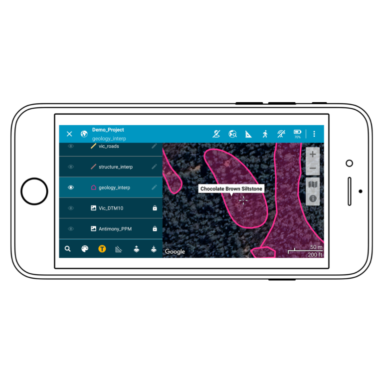
Discover Mobile is the must-have field GIS solution available for both MapInfo Pro and ArcGIS Pro platforms. Discover Mobile brings all your office-based data into a convenient mobile app for you to go into the field.
Discover Mobile is available on both Android and iOS from the Google Play Store and App Store for download. Discover Mobile is compatible with most phones, iPhones, tablets and iPads. As long as your mobile device has a Digital Compass, Three Axis Gyro and Accelerometer sensor (which most do) you are ready to make the most of all the power in Discover Mobile. A great feature of Discover Mobile is its ability to work offline in those remote locations.
View all your desktop GIS data out in the field in one convenient app from grids, images, point, line and polygonal data. All the attribute data associated with your layers can be easily viewed as text labels or in a datasheet view. See where you are on the map using the inbuilt GPS capabilities. Want to connect to a higher precision GPS, we have thought of that too!
Throw away your paper maps and navigate in the field with your own custom layers. Discover Mobile from the ground up was designed for navigating in remote locations. Use the device GPS, digital compass, waypoint navigator, location search or simply locate your position on the map with your current location. Having your personalised data to navigate with makes field work so simple.
One of the strengths of Discover Mobile is data collection. Simply setup all your data collection rules and layers on the desktop and transfer to your field crews. Use the custom dropdowns, enforce numerical ranges, default data entry values, increment values, take photos, record structure measurements are just a small selection of what is capable with data entry. And don’t forget Discover Mobile digitises structures, point, line and polygon objects via GPS or manual entry.
You can view and collect data with Discover Mobile but as an added bonus it has some fantastic analytical tools. From analysing your structure data in a stereoplot, capturing the track you have walked, analysing polygon areas to measuring distances these are just a few tools available. Want to analyse your numeric or text data by thematic styles, Discover Mobile can do that.
This where Discover Mobile excels, getting data on and off your device is made easy. Choose between transferring the project via Cloud storage or even simpler with the WiFi Sync functionality. With one or two buttons clicks your project goes to and from the mobile device.
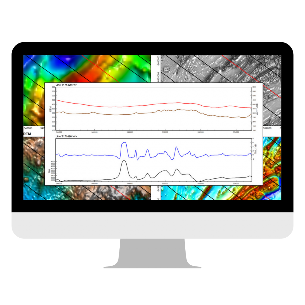

Application for analysing and presenting geophysical data in profiles, maps and 3D displays
PA Explorer is an application for analysing and presenting geophysical data in profiles, maps and 3D displays. The information that can be analysed by this software includes single or multi-channel data acquired from airborne or ground surveys, including electro-magnetics (AEM) and potential field (gravity or magnetic) data.
PA Explorer will deliver more results from your existing software investments through better use of visualisation and cross-product integration.
PA Explorer provides you with a range of interpretive enhancement tools that include line, section, grid and voxel gridding, filtering, calculators and toolkits.
PA Explorer provides a rich environment for building interpretations that cover anomaly picking, map interpretations, section interpretation and 3D geological model building. The Feature Manager utility uses a 3D object database to capture your interpretation elements from which you can build sophisticated 3D targets, models, surfaces, faults, geological units and intrusions.
")


